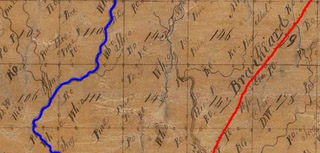
The road that’s shown – cutting across the entire county, from the southwest corner at Chattoogaville to the northeast corner at Trion or “Island Town” -- is called the “Road to Brainiard (Brainerd)” in the Section 4, District 6 survey map, and is referred to as the “Tennessee Road” in Section 4, District 14. Northeast of what is now Trion, this path undoubtedly would have been used for at least some of the Cherokees coming from Georgia to Ross’ Landing (modern day Chattanooga, TN), in preparation for their removal to the West. A few miles of it can be marked with some confidence.
But before merging, the roads leading most directly from military round-up camps or forts in Chattooga County actually would have been on either side of this artery. Prisoners who marched from Ft. Likens and Ft. Lovell in Alabama, from the southwest, most likely would have traveled along what was then called Broom Town Road (today’s Menlo-LaFayette Road, GA 337), while those coming from the Georgia sites of Cedartown, Camp Malone, and Ft. Wool, from the southeast, through Kar Tah or “Dirt Town,” would have traveled along a route roughly congruent with the original Highway 27, or Summerville Road.
For these two Trail of Tears paths, if we don’t have reliable maps from the time period (pre-1838), then how do we mark them with signage?
There are basically two options. The first option would be to find the oldest maps and road descriptions available for these two roads, and then try to extrapolate what, if any, variations there might have been from the modern-day roadbeds. This is usually a hit-or-miss kind of method, but can sometimes produce good results.
A second method would be to focus on placing signs and possibly wayside exhibits and markers at key sites along the original path that were known to be there when the Cherokees passed by. This method is sometimes used when original road alignments are unclear, and this may be the best option, in this case – depending on what primary source records eventually surface.
Here's one early source describing the northern road, the Broomtown Road, from J. A. Sartain’s History of Walker County, Georgia, p. 23:
INDIAN TRAIL BROOMTOWN VALLEY.
When the pioneers began to settle in Broomtown Valley, (so-called from an Indian chief, “The Broom”, whose headquarters were near Alpine), they found an Indian trail running through its entire length. This trail was sometimes known as the Five Spring trail, from the fact that it passes, in its course, near five beautiful, cold, clear springs of pure water. The first of these springs is on the L. L. Clarkson place. Another is on Arthur Clarkson’s place, somewhat back of Trinity church. The others are in Chattooga County, known as the Teloga Spring, the Knox Spring, and the Barry Springs, just across the Georgia-Alabama line, near Alpine church. It is quite probable that the first road built through the valley followed exactly this old Indian trail, and that the present Broomtown road follows approximately this same trail.
Bill Barker of the Chattooga County Historical Society (and GA chapter Trail of Tears Association member) sent me his observations, as well:
The important roads for Chattooga County would be:
GA 337 (The Broomtown Road)
It skirts the eastern side of the Lookout Mountain chain and in Cherokee days ran from the village of Chief Broom ... It ran from Broomtown in Alabama to Crayfish Springs (Present day Town of Chickamauga).
According to Sartain's History of Walker County, springs were along this trail about a day's journey apart, by walking (the site of these springs would be signage candidates). Just over in Alabama near Barry Spring there is a Cherokee removal internment site (Ft. Likens) marked by signage. Sequoyah is said to have lived along this trail in the Alpine community between the Alabama line and the Menlo City limits.
The Cherokee Town of White Oak was on the northern portion of the road, with part in Walker County. Most likely Cherokees would have been moved along this road from this internment camp to Fort Cumming in Lafayette.
GA 48 (Menlo to Summerville)
Runs from Menlo to Summerville. Indian Agent Montgomery's house still stands at the corner of Fish Hatchery Road and GA 48. Raccoon Town is bisected by GA 48; it lay alongside Raccoon Creek, the present site of Berryton. In Summerville the oldest frame house, circa 1836, is in dilapidated condition on this road. Its connection with the Cherokees has not been determined.
Ga 114 (Rome to Lyerly)
Chief Dirtseller's camp was outside Lyerly on Dirtseller Mountain and most likely figures in here. Chattooga Village was located along this trail, just inside the Alabama line (It was the largest Cherokee village in the county).
US Highway 27 (Rome to Lafayette)
This was the main trail through the central part of the county and several Cherokee towns were located along this road: Kar Tah (Dirt Town) on the south side of Taylor's Ridge, and Island Town, located along the Chattooga River in present day Trion, GA...
Summary
I believe these are the major sites we need to nail down with research and determine what signage would be required to establish the Trail.
Bill Barker


