French and Indian War 1754 - 1763
A Brief History (Maps Below)
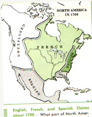
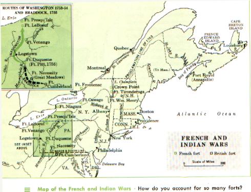
In the early part of the eighteenth century, the trans-Appalachian region of North America remained much as it had been for the preceding centuries. Some trappers and backwoodsmen—Frenchmen from Canada and Englishmen from the British colonies—traveled through its woods and rivers, but the principal occupants of the region were Native Americans and a great diversity of wildlife. As the British colonies became more populated and prosperous, their citizens began to look towards the rich lands across the Appalachian mountains as providing new opportunities for settlement and economic growth. The French, who claimed the entire watersheds of the Mississippi and St. Lawrence Rivers—which included the Great Lakes and the Ohio River valley—became worried about British encroachments into this region and so they moved to set up a series of forts, including at Crown Point on Lake Champlain, and on the Wabash, Ohio, Mississippi and Missouri Rivers. The British, meanwhile, built their own forts at Oswego and Halifax, the government granted lands in the Ohio Valley to the Ohio Company and adventurous traders set up bases in the region.In 1750, British and French representatives met in Paris to try to solve these territorial disputes, but no progress was made. In 1752, the Marquis Duquesne was made governor-general of New France with specific instructions to take possession of the Ohio Valley, removing all British presence from the area.. The following year, he sent troops to western Pennsylvania where they built forts at Presque Island (Erie) and on the Rivière aux Boeufs (Waterford). At the same time, Robert Dinwiddie, Lieutenant Governor of Virginia, was granting land in the Ohio Valley to citizens of his colony, setting in motion the events which inevitably led to the French & Indian War.
Dinwiddie, hearing of new French forts on the upper Allegheny River, sent out a young Virginia officer, George Washington, to deliver a letter demanding that the French leave the region. This mission was, not surprisingly, a failure, but when passing through the region where the Allegheny and the Monongahela form the Ohio, Washington noted that the point of land at the junction was an excellent spot for a fort. In early 1754, in response to Washington's suggestion, the British started to build a fort there, Fort Prince George, but French troops soon arrived and threw them out. The French completed the fortification, renaming it Fort Duquesne. Washington, meanwhile, had been sent out with a contingent of troops to help establish British control in the west, and when he heard of the surrender of Fort Prince George, he set up camp in Great Meadows, southeast of Fort Duquesne. Washington received a report that a nearby French contingent intended to attack, so he launched a preemptive strike against the French camp. This was the first engagement of the yet undeclared French & Indian War. Though Washington won that engagement, he was soon defeated by a superior force sent out from Fort Duquesne, leaving the French in command of the entire region west of the Allegheny Mountains.
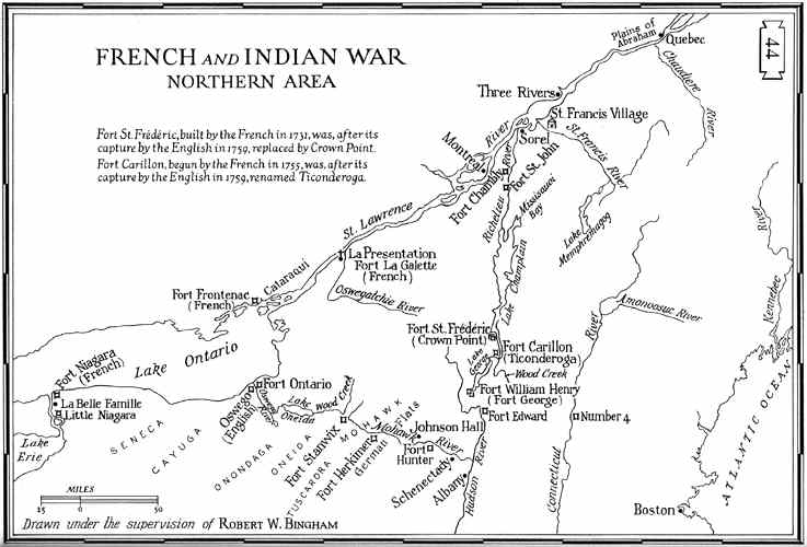
Early the next year, 1755, Major General Edward Braddock was sent to America as commander-in-chief of the British forces in America. He quickly set in motion plans to capture Fort Duquesne, leading his troops west from Virginia in June. Meeting the French 10 miles east of Fort Duquesne, the British were defeated with heavy losses, including Braddock who died four days after the battle. Once again the French had maintained their grip on the Ohio Valley. In the north, British luck was better, for they won a battle on Lake George and established two forts just south of the French fortification (Fort Frederick) at Crown Point on Lake Champlain. These were Fort Edward on the Hudson River and Fort William Henry at the southern end of Lake George.
Despite all this military activity, it wasn't until 1756 that war was officially declared between the French and British. The military activity that year and the following was relatively inconclusive, though the French generally had the upper hand, capturing Fort Oswego on Lake Ontario and Fort William Henry. In 1758 the tide began to turn and the British started to take the upper hand. They launched a three part attack on the French, against Louisbourg on the Atlantic Coast, Fort Carillon (Ticonderoga) on Lake Champlain, and Fort Frontenac at the eastern end of Lake Ontario. That summer the British finally captured the city of Louisbourg, Nova Scotia, establishing control of the Bay of the St. Lawrence. And while they failed in an assault on the Fort Carillon, they did gained control of Lake Ontario by capturing Fort Frontenac with troops under Lt. Colonel John Bradstreet. In July, Brigadier General John Forbes assembled a large force to move against Fort Duquesne. Despite an initial setback, Forbes had great success. He held a council at Fort Bedford with the Indian tribes of region, establishing peace between them and the British. When the French realized they would no longer have Indian allies, and knowing their their communication with Montreal was cut off with the capture of Fort Frontenac, they quickly abandoned Fort Duquesne, destroying the fort as much as possible. Forbes occupied the site, which he soon had rebuilt and renamed Fort Pitt, establishing British control of the upper Ohio Valley for the first time.
The news in 1759 continued to be positive for the British. Major General Jeffrey Amherst took over from Abercromby as commander-in-chief of the British forces and he soon captured both the forts at Ticonderoga and Crown Point and also that summer other British forces captured Fort Niagara. Quebec was the strongest fortress in Canada, the lynchpin of French power in North America and the British knew that if they were able to capture Quebec, the rest of the country would soon fall into their dominion, so in early 1759 they planned the largest attack of the war, a combined force of about 9,000 soldiers under General James Wolfe and a fleet of 20 ships under Admiral Charles Saunders. The British lay siege to Quebec from June 27th until September 18th, when the French surrendered their garrison in the city. This was the turning point of the war, with an eventual British victory all but certain. By the end of the year, the British had control of almost all of North America, other than Montreal and Detroit. By the end of 1760, these two sites fell to the British. Amherst's campaign against Montreal resulted in the surrender of that city in September and one week later Major Robert Rogers took over Fort Detroit. The British had gained all of North America from the French.
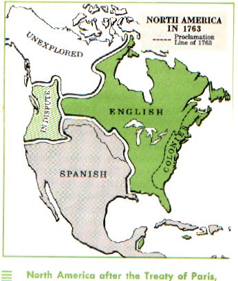
Quebec was the strongest fortress in Canada, the lynchpin of French power in North America. The British knew that if they were able to capture Quebec, the rest of the country would soon fall into their dominion, so in early 1759 they planned the largest attack of the war, a combined force of about 9,000 soldiers under General James Wolfe and a fleet of 20 ships under Admiral Charles Saunders. The British lay siege to Quebec from June 27th until September 18th, when the French surrendered their garrison in the city. This was the turning point of the war, with an eventual British victory all but certain. This map, issued as the attack on Quebec was forming, would have served the reading public in London both as a reminder of strength of the citadel, but also as a map upon which to follow the news of the attack as it progressed during the summer. This de facto control was confirmed two and a half years later at the Treaty of Paris, February 10, 1763, which gave all of North America east of the Mississippi, other than New Orleans, to the British. The French also turned over their claims of New Orleans and the lands west of the Mississippi to Spain, as compensation for Spain's surrendering Florida to the British. Though the European-based war ceased, the Native Americans in the west remained hostile to the British. The Pontiac Rebellion and other Indian hostilities lasted until the end of 1764, at which time peace finally reigned in North America. This peace, however, would last only a decade until a new war, the Revolution, began a new episode in the history of the continent.
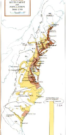
Colonies 1720
French & Indian Land before defeat
French-Indian Wars with Pennsylvania
French-Indian Land after defeat, now English Land
French-Indian Conflict in the North
